Transportation
Issues
 Still the 'Good Roads State'?
With more than $5
billion in highway construction
in progress, the
N.C. DOT is building new roads
as fast as
it can. But is it miles enough soon
enough?
Above, the $120 million
Neuse River Bridge at New Bern opened last September.
Below right, the new I-85 Bypass at I-40
just east of Greensboro should be completed in three
years at a cost of $275 million.
 By
Richard Rogoski By
Richard Rogoski
From
the mountains to the coast, North
Carolina is experiencing
phenomenal growth in people and
their cars. And the state
Department of Transportation is
trying to stay ahead of the
traffic curve by systematically
widening existing highways and
building new ones as fast as it
can.
It all comes at a price, of
course, which in this case starts
at $3.95 billion. That's the
amount tied up in the N.C. DOT's
10 largest highway projects now
under construction. The tab rises
to more than $5 billion when you
add the $1.2 billion spent last
year for resurfacing nearly 1,700
miles of primary and secondary
highways, replacing 68
substandard bridges, and
installing 405 miles of median
guardrails.
The purpose? To maintain the
state's 78,000 miles of highways
-- only Texas has more -- and to
hold on to North Carolina's
reputation as "The Good
Roads State." How the DOT
thinks it can solve the state's
traffic problems can be seen in
the new construction projects,
all of which are designed to help
the state cope with the surge in
population. Here is an overview:
* The
Charlotte Outer Loop
* The
Raleigh Outer Loop
* Interstate
26 Connector
* Greensboro
Bypass, I-40 Widening
* I-85
in Rowan County
* Bypasses
Around Jacksonville, Wilson,
Manteo
* U.S.
74 Bypass at Rockingham
Also:
Five
Recently Completed Projects
The
Charlotte Outer Loop
With a price tag of more than
$1.2 billion, I-485, as the loop
is known, is being built in
sections, explains Calvin
Leggett, director of planning and
programming for the NCDOT. The
first 26-mile section, which
makes up the southern arc of the
loop, has already been
constructed. But the entire loop,
totaling about 65 miles, is not
scheduled for completion until
some time between 2006 and 2013
-- even though the first contract
for the project was let in May
1988, Leggett says. And while
this project is high on the DOT's
list of priorities, there are
still some sections of roadway
that have yet to be budgeted for,
Leggett admits.
Rapid and continued growth in the
Charlotte area has made an outer
loop a necessity, Leggett notes.
So when it's completed, it will
"provide a bypass for I-77
and allow traffic to go around
Charlotte," he says.
Additionally, it will serve as a
bypass for U.S. 74 and also will
help connect those communities
that have developed on the
outskirts of the city, Leggett
adds.
Yet the prospect of having to
wait another six years or more
for the outer loop to be
completed is disconcerting for
many Charlotte officials and
business leaders. "We need
it sooner than later," says
Bob Morgan, group vice president
for public policy at the
Charlotte Chamber of Commerce.
"Charlotte is the largest
metropolitan area in the U.S.
without an outer loop."
While Morgan agrees that I-485
will provide "additional
highway capacity to get around
Charlotte," he also says it
will provide surrounding areas
with additional access
"into" Charlotte. And
since 100 percent of the outer
loop will be in Mecklenburg
County and 80 percent within the
Queen City, the loop is destined
to have an even greater economic
impact on Charlotte and
surrounding areas since it will
serve as a magnet for business
development. "Every time you
finish a segment, it opens up a
new submarket," Morgan says.
However, Morgan dismisses critics
who say the outer loop will
detract from the inner city and
lead to suburban development.
"Our central business
district is not in decline,"
he says. "And if you have an
outer loop, that becomes the
defining line for suburban
development." He also cites
a recent Federal Highway
Authority study: "Cities
without loops have more suburban
sprawl than those with
loops," Morgan says.
The
Raleigh Outer Loop
Raleigh has been wrestling with
the pros and cons of an outer
loop since 1992, when the DOT
awarded its first contract. With
cost estimates now reaching $1.2
billion, Raleigh's outer loop, or
I-540, is in a virtual dead heat
with Charlotte's loop as the most
expensive road project under
construction. But when it's
finally completed sometime in
2025, Raleigh's loop will be a
six-lane, 71-mile highway that
will encircle the Capital City
well outside of the existing
I-440 beltline.
Raleigh's outer loop is being
constructed in segments that will
eventually come together to
complete the circle. With
construction moving in an
easterly direction, part of the
roadway, designated the Northern
Wake Expressway, already has been
built from I-40 to Leesville
Road. Three other segments of
this northern arc -- one running
from Leesville Road to Creedmoor
Road; one running from Creedmoor
to Six Forks Road; and one
linking Six Forks with Falls of
Neuse Road -- should be open by
the end of this year, Leggett
says.
According to Leggett, I-540 will
eventually serve as a true loop,
rather than doubling as a bypass
the way Charlotte's I-485 will.
But he admits it also will help
relieve congestion on radial
roads leading to I-440 and along
some stretches of I-40 -- which
has become notorious for
rush-hour traffic jams in the
vicinity of Research Triangle
Park. In addition, it will
provide North Raleigh residents
with a more direct route to RTP
and Raleigh-Durham International
Airport, he says.
Harvey Schmitt, president and CEO
of the Greater Raleigh Chamber of
Commerce agrees. "It
increases the whole mobility of
northern Wake County." It's
also serving as a magnet for
residential and commercial
growth, he says. "Any time
you have a major transportation
corridor, you open up
opportunities for business
development. People and
businesses tend to cluster around
major transportation
routes."
But even those northern sections
of Raleigh's outer loop that are
not yet open are driving
development. Wakefield
Plantation, for example, is a
2,200-acre development located
between North Raleigh and the
town of Wake Forest that will be
served by a section of I-540
scheduled to open in 2002. The
upscale community features a
Tournament Players Club golf
course, homes with price tags
hitting $2 million and 500 acres
of commercial space that already
has become one of the hottest
addresses in the Triangle.
Interstate
26 Connector
While outer loops can serve dual
functions, the DOT is working on
a number of widening and
road-building projects that will
ultimately increase traffic flow
and bring greater economic
development to nearby cities and
towns. But in the case of
Interstate 26, the state's
economy also will get a boost.
A new 30-mile connector road is
being constructed from the town
of Mars Hill to the Tennessee
line. Located northeast of
Asheville, the new thoroughfare
will be an extension of I-26 and
will create a more direct and
safer route between Johnson City,
Tenn., and Asheville. "The
existing I-26 is a winding,
two-lane highway," Leggett
says. "The new one will be a
four-lane highway."
Leggett says that many
manufacturing plants in the
Midwest truck their products
through the mountains and across
North Carolina to the Port of
Wilmington. Opening a new route
will improve access through the
mountains and reduce the truck
traffic on I-40, he says.
Although the cost of this project
is $330 million, 80 percent of
the bill will be picked up by the
federal government, Leggett says.
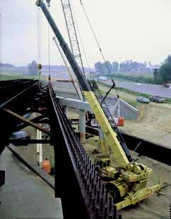
Greensboro
Bypass, I-40 Widening
The area around Greensboro also
gets its share of truck traffic.
But two projects should help ease
congestion. The Greensboro I-85
Bypass will be a 14.7-mile road
tying together I-40 and I-85 in
eastern Guilford County with I-85
just southwest of Greensboro
(photo, left).
The first contract for this
project was let in September
1997, and the bypass should be
completed in 2003 at a total cost
of about $275 million, Leggett
says. When completed, it will
allow regional traffic to flow
around Greensboro while still
affording local traffic the
opportunity to drive downtown.
Another project that will impact
the Greensboro area is the
widening of I-40 from Greensboro
to Winston-Salem. Although this
project actually began in May
1993 when the first contract was
awarded, it isn't scheduled to be
completed until September 2002.
Its cost: about $235 million.
Motorists who regularly travel
this stretch of I-40 have gotten
used to the traffic snarls and
barricades but it won't be long
before this 10.9-mile length of
interstate is transformed from
four lanes to eight.
Penny Whiteheart, interim
president for economic
development at the Greensboro
Area Chamber of Commerce, says
both road projects will benefit
Greensboro. She says the I-40
widening project will bolster the
economies of both Greensboro and
Winston-Salem by increasing the
capacity along I-40, but
Whiteheart sees the I-85 Bypass
as having a more direct impact on
Greensboro. "The I-85 Bypass
will open up the southern part of
Guilford County," she says.
Whiteheart says Greensboro will
extend water and sewer lines to
the county's southeastern part as
a way to facilitate residential
development. She adds that the
availability of water and sewer,
combined with the I-85 Bypass,
also will facilitate commercial
growth in that area.
Plus, the I-85 Bypass that is now
under construction will
eventually become part of a loop
around Greensboro. As to when
this loop will be completed,
however, Whiteheart can only
guess. One-half of the loop's
western segment should be
completed in 2005, she says. But
the second half is not even on
the DOT's five-year plan.
I-85 in
Rowan County
Another DOT project involving
I-85 is in Rowan County, just
northeast of Charlotte.
Approximately 13.2 miles of this
road are being widened from four
lanes to eight at a cost of $200
million. With the first contract
having been awarded in June 1997,
this project should be completed
in 2005. The most important
reason for widening this stretch
of I-85 is simply to relieve
traffic congestion. "That
whole corridor is
overburdened," Leggett says.
The problem actually begins just
south of Lexington where the
merging of U.S. 52, I-85 and
Business I-85 means that 10 lanes
of traffic are merging at a
single point, Leggett says. The
widening of I-85 in Rowan County
also means the Yadkin River
Bridge will have to be replaced,
according to Leggett, who also
notes that similar congestion
occurs around China Grove in the
southern part of the county. And
Salisbury isn't much better.
According to John Casey, chairman
of the local affairs committee at
the Rowan County Chamber of
Commerce, the widening of I-85 is
necessary to keep up with the
growth his county is
experiencing. "This area is
growing very fast because of its
proximity to Charlotte," he
says. But Casey also says the
widening of I-85 needs to
continue into neighboring
Cabarrus County to avoid a
bottleneck there. "You'll be
going from three lanes to eight
lanes, then down to two lanes in
Cabarrus County," he says.
Bypasses
Around Three Eastern Cities
Traffic congestion and converging
highways also has led the DOT to
begin building the Jacksonville
Bypass. Served by U.S. 17 and
N.C. 24, the city of Jacksonville
borders the northern part of Camp
Lejeune Marine Corps Base. The
7.4-mile bypass, which will link
with U.S. 17, is scheduled for
completion in 2005 at an
estimated cost of $140 million.
Work began in March 1998 with the
awarding of the first
construction contract.
Another bypass now under
construction in the eastern part
of the state will help relieve
congestion in and around Wilson.
The 13.4-mile Wilson Bypass will
allow east- and west-bound
traffic on U.S. 264 to avoid
town. "The existing U.S. 264
was built in the 1950s and now is
a commercial strip," Leggett
says. "It's literally a city
street there."
Since U.S. 264 also serves as a
major connector between Raleigh
and Greenville, the new bypass
will allow for the free flow of
through traffic, he adds. The
first contract was let in
November 1995, and this $125
million project is scheduled for
completion in 2003.
The growing popularity of coastal
towns and beaches has taken its
toll on both residents and
tourists. That's why the DOT
decided to build a bypass around
the Dare County town of Manteo,
which is located on the Croatan
Sound side of Roanoke Island.
U.S. 264 and U.S. 64 merge near
Manns Harbor, where they form a
single roadway that serves both
Manteo and Nags Head. But the new
10-mile, $125 million bypass that
will be located just south of
Manteo will link U.S. 264 with
U.S. 64 at N.C. 345.
And while traffic congestion in
this area is the main reason for
building this bypass, Leggett
says it will also serve as an
additional hurricane evacuation
route. This project, which had a
start date of March 1998, is
scheduled for completion in 2002.
U.S. 74
Bypass at Rockingham
Bisecting Rockingham and Hamlet,
U.S. 74 is a major route to
Wilmington. But traffic
congestion around these two towns
is compounded because U.S. 1 and
U.S. 220 also converge in
Rockingham. Yet the real problem
is U.S. 74, which constitutes the
only two-lane segment left in
this major highway system. In
order to allow high-speed
regional traffic on U.S. 74 to
circumvent both towns, the DOT is
constructing a 13.1-mile bypass
just south of each town.
The first contract was awarded in
December 1996 and the project
should be completed by January
2001. And even though this bypass
carries a $120 million price tag,
it will become part of the I-74,
I-73 corridor -- an interstate
system that eventually will link
Detroit to Charleston, S.C., by
cutting diagonally across North
Carolina, Leggett says.
Under the National Highway System
Designation Act of 1995, the U.S.
Department of Transportation
labeled this corridor a
high-priority project. But it's
up to each state involved to
either build new roads or bring
existing roads up to federal
highway standards. In the
majority of cases, North Carolina
has been able to use existing
highways like U.S. 220, U.S. 74,
U.S. 73, U.S. 311 and U.S. 52 as
links to highways in adjoining
states.
Beginning in Detroit, the I-74
and I-73 corridor runs through
Cincinnati and Portsmouth, Ohio,
then heads south through the
Triad and into Rockingham. At
Rockingham, I-73 will turn
southwest into South Carolina,
then head east toward Florence
and Charleston. I-74, however,
will continue to head southeast
toward Charleston.
According to DOT projections,
most of the North Carolina
portion of this interstate system
should be open between 2005 and
2010.
Five
Recently Completed Road Projects
Highway road
projects do get finished. The DOT
has recently completed five major
projects, the most spectacular
being the Neuse River Bridge,
which is pictured on the cover of
this issue of the magazine. It
opened last September at a cost
of $119.5 million. The view in
the photo at left looks from New
Bern over the river toward
Havelock.
Neuse River Bridge.
Distance: 1.5 miles.
Year Let: 1995.
Completion Date: September 1999.
Cost: $119.5 million.
U.S. 64 (Edgecombe County
to Martin County).
Distance: 20.1 miles.
Year Let: 1995.
Completion Date: November 1999.
Cost: $94.2 million.
Interstate 74 (I-77, U.S.
52 connector).
Distance: 12.8 miles.
Year Let: 1991.
Completion Date: December 1999.
Cost: $83.6 million.
I-485 (Charlotte Outer
Loop).
Distance: 1.74 miles.
Year Let: 1996.
Completion Date: April 2000.
Cost: $23.3 million.
US 264 Bypass.
Distance: 3.32 miles.
Year Let: 1998.
Completion Date: May 1999.
Cost: $22.5 million.
Return to
magazine index
|
|
|
|
|